 - v2.jpg)
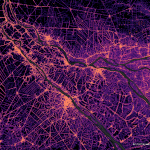 Image derived from WorldPop Global 2 data. Distributed under the Creative Commons Attribution 4.0 International (CC BY 4.0) license
 Counting people using geography!
Data from satellites can help us count people in some of the remotest parts of the world. Join WorldPop in learning how geospatial data is used to count people from a distance.
For younger children, they can use Lego to learn how we can map the number of people in an area just by looking at it. This will involve counting the number of Lego minifigures, and translating this to a Lego grid where they will match the colour of Lego bricks to the number of minifigures in that area.
For older children they will be able to better understand how this data can be used to help people in some of the remotest parts of the world. Firstly they will be able to estimate the number of people affected by a natural disaster by looking at the number of damaged buildings, and they will try to work out where they could place a new school so that more children in a rural town have access to an education.
All of this will build an understanding of why geography is important in mapping some of the most vulnerable communities and how WorldPop is helping to do this.
You may also like
Maths with a twist
Fluid dynamics is a subject with a long history representing a virtual parade of famous mathematicians. Yet, we continue to make discoveries and find applications that impact on o ...Read More
Highfield Campus
Healthy coasts, smart choices
Coasts and oceans are busy, shared places. They are home to wildlife, give us food, move people and things around the world, and are places where many of us live, work and have fun ...Read More
Boldrewood Innovation Campus